Hiking in Switzerland - Three Valleys Hike in Kandersteg
Please note: This post may contain affiliate links. See our disclosure to learn more.

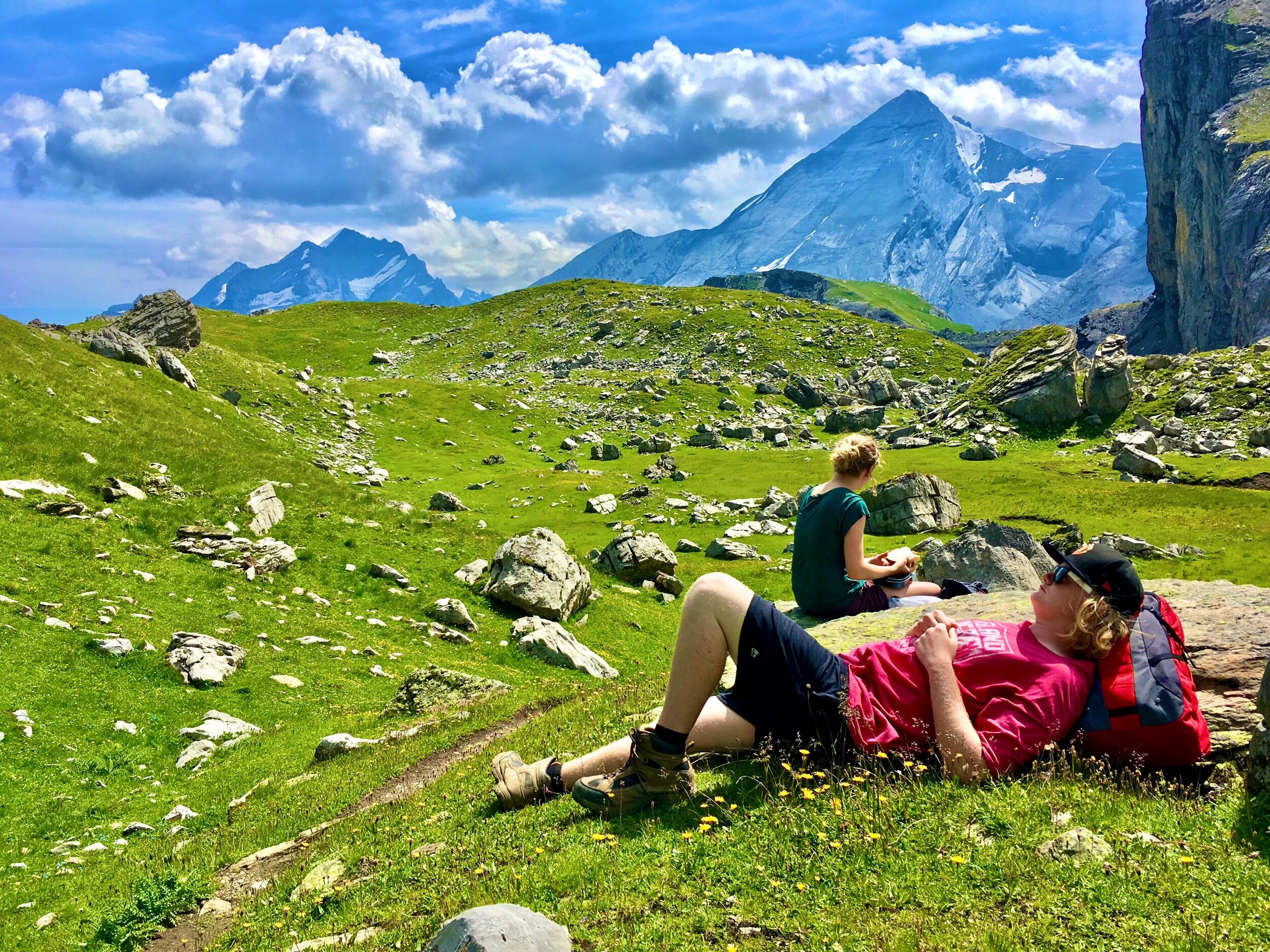
If you look closely, you might be able to spot the hikers on the right side ridge heading towards KitKat mountain.
Destinations > Europe > Switzerland > Hiking in Switzerland
Hiking in Switzerland
Hiking the Swiss Alps is no joke. Our guides informed us that this particular hike was rated a 3 out of 5 on the difficulty scale and considered a "family-friendly" hike. I suppose that Swiss people are generally more fit than Americans and that hiking up to high altitudes is a common Swiss family activity - however, we found it fairly challenging!


Three Valleys Hike: Kandersteg
The three valleys hike is located just outside of Kandersteg - one of the most beautiful areas in Switzerland! It’s also a hikers dream, and the landscape is simply mind blowing. I’ll never forget the first time I saw a glimpse of Switzerland in the movies - when it was used as the filming location for the bungee jump off the dam in the James Bond movie Goldeneye (located at Contra dam in the Vezasca Valley). That pretty much hooked me onto wanting to visit Switzerland! And this hike made me feel complete!
James Bond has been filed in many places in Switzerland, including: Schilthorn mountain from On Her Majesty’s Secret Service, Furka Pass from Goldfinger, and the slopes of St Moritz from The Spy Who Loved Me). The mountains around Grindelwald in the Jungfrau region were also used for Alderaan in Star Wars Episode III. For a little trivia, do you know what scenes were shot in Switzerland from the following films: Iron Man 3, X-Men: First Class, and Sherlock Holmes: A Game of Shadows? Make your guess in the comments section at the end of this article!
Hiking the Three Valleys ridge from Kandersteg is a great way to taste what types of landscapes and mountain ridges that Switzerland has to offer. It was one of our most memorable experiences on our adventures in Switzerland and we highly recommend it for the beauty, the sense of awe that it gave us, the feeling of Swiss heritage, and the memories that have stayed with us over the years and that we still use to tell amazing stories of this area. It is a very nostalgic hike!
A guide is necessary for this hike, as paths are not always clearly marked or obvious.
Additionally, you can learn more about Switzerland’s culture by reading Switzerland Culture Smart book.

The Path of the Three Valleys Hike
The three valleys hike is just outside of Kandersteg. We split it up into two days so we could experience staying in one of the huts on the mountainside in the Ueschinen Valley. Trust us, the views are so amazing that you won’t want to just squeeze this hike into a single day!
We booked this particular 2-day hike with the Kandersteg International Scout Center for a small fee. The two guides that they provided were very helpful!

Day 1
The first part of this hike takes about 3 hours to walk/hike and brings you into the Ueschinen Valley (the Inner Üschene) and up to the Ueschinenhütte.
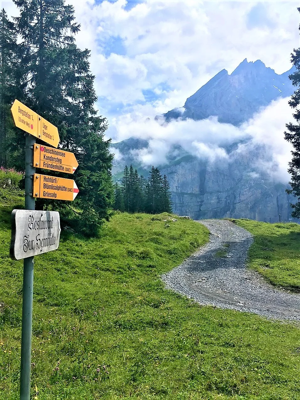
The trail starts out near the Kandersteg LKS Parking Area and runs along the Alpbach River, on/near the Ueschenestrasse road, and ends at the Ueschinenhütte.
This part has some amazing things to see by itself, especially the views of the surrounding mountains, clouds, and the Alpbach River.
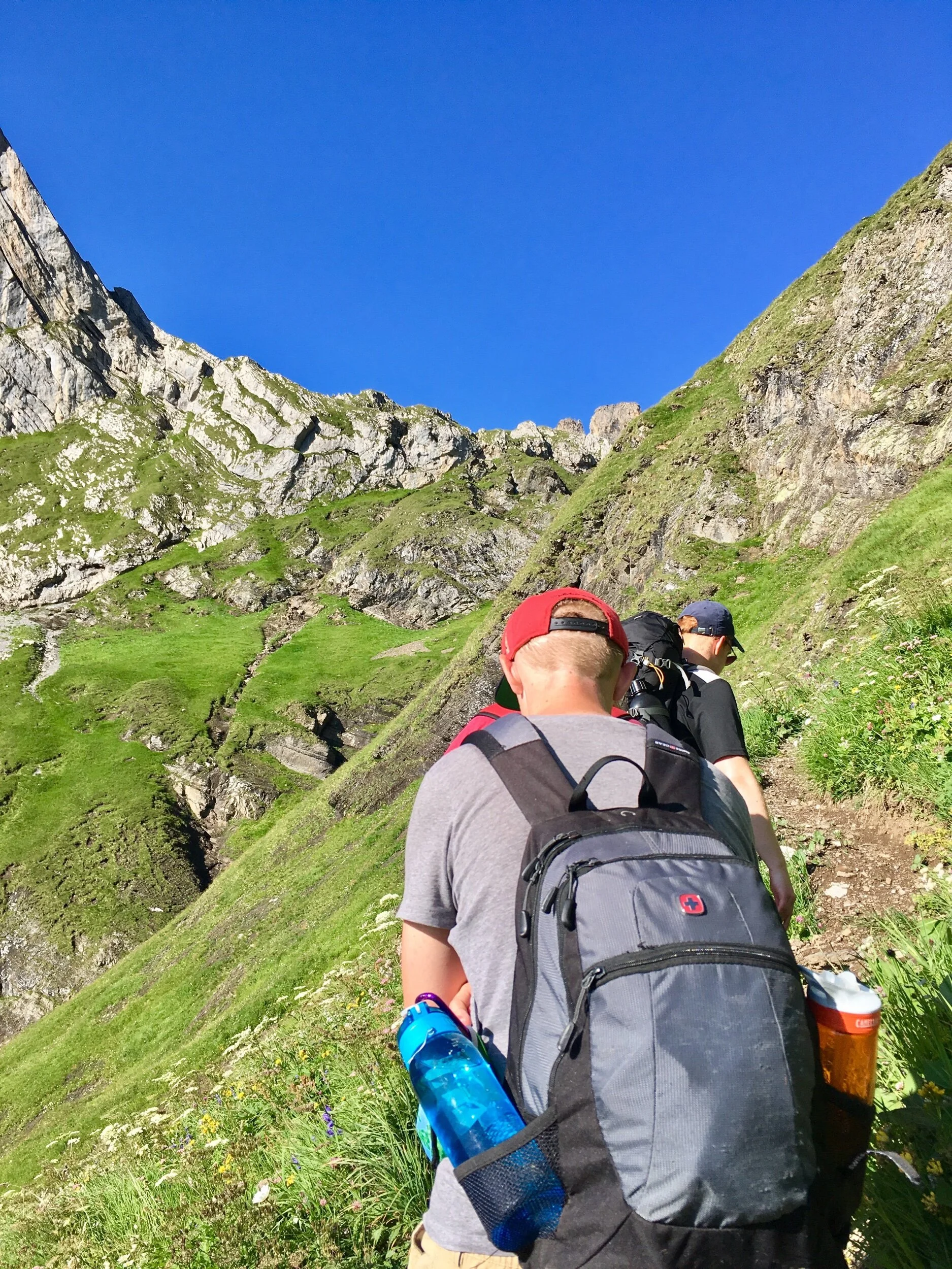
The hike can be quite challenging for some folks - especially considering that there is a significant difference between a “hiker” and a “mountain hiker”. It has a decent incline and will be quite challenging for novice mountain hikers, but it’s a nice treat - workout wise - for intermediate mountain hikers.


This climb was part of the “hike ‘n climb” package from the Kandersteg International Scout Center.
We stopped at the hütte to eat a bagged lunch, and then walked back a bit to do some intro level rock climbing in the afternoon - around this area - before enjoying a hot dinner and conversation at the hütte and spending the night. The hut is a perfect place to spend an evening looking out over the valley and listening to the cow bells and river not far away.

Day 2
Although you had been hiking through one of them, to actually see all three valleys at once, you will have to keep hiking upwards on day 2.
So, the following morning we started our path toward the ledge. The inclines get steeper and and trail gets narrower. There was an area that you have to be fairly careful at, as a slip could mean a far drop, but even the most weak-kneed of our group was able to navigate it with the assistance of the guides. We then stopped at a grassy cliff edge with spectacular views just before the top (coordinates: 46.45090482308453, 7.60121859626292). Just wow! Even though it’s Switzerland, and not Austria, this is a magical “Sound of Music” moment!

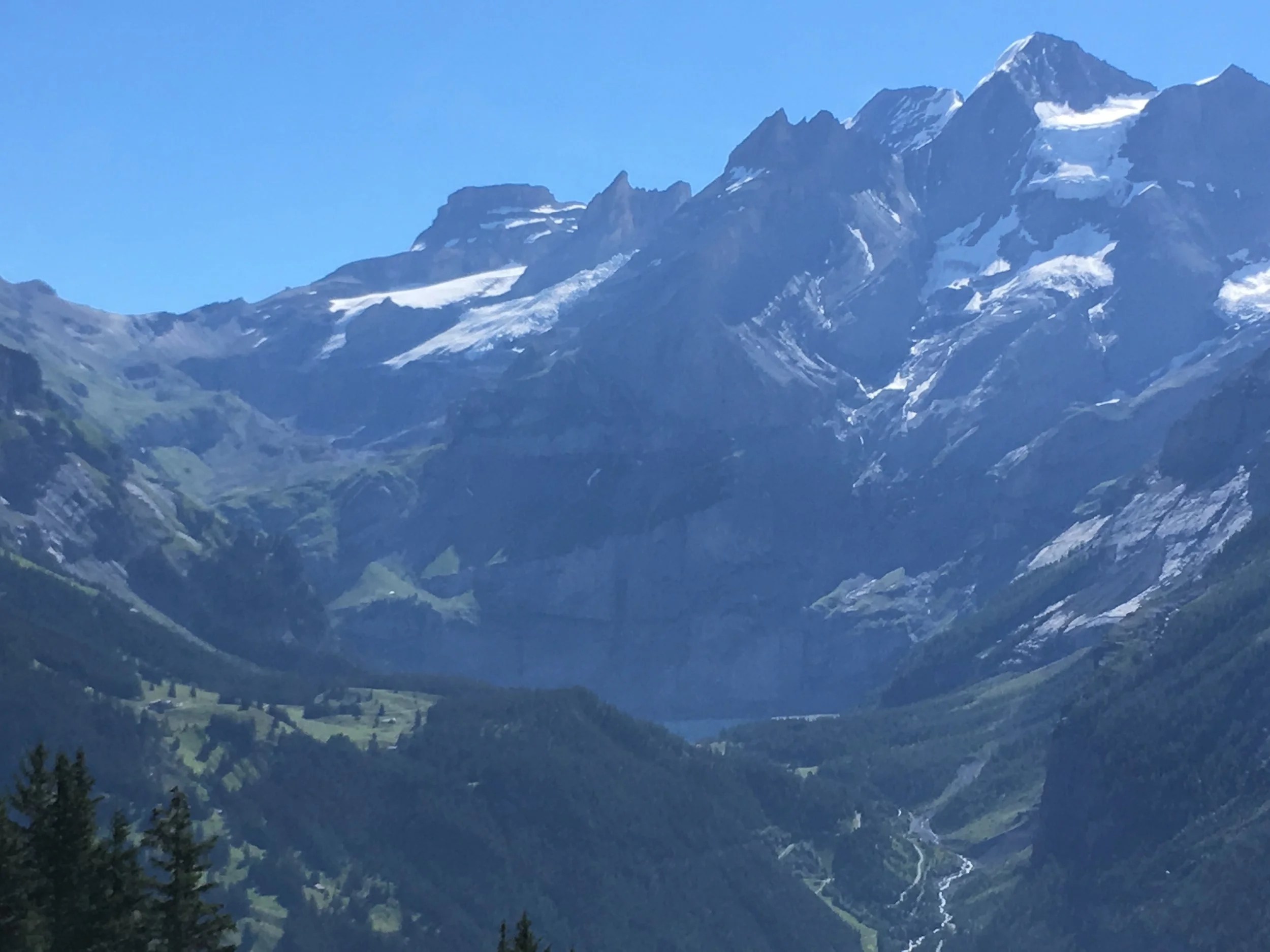
We then worked our way up a narrow, steep, rocky edge (coordinates: 46.451712432601504, 7.598629482026803). Some parts here are quite difficult to see - at some points you are just hiking upwards through grassy areas. However, your goal, and it’s fairly easy to see, is making it up to the Schedelsgrätli ledge. Once you arrive you’ll be provided with some amazing views of the Alps and Adelboden.

The top of the ridge is windy and narrow, and it didn't help that more than half of us had a fear of heights. But once we reached the top we were greeted with these awe-inspiring views and a mountain-high feeling of accomplishment.

Crossing the ledge, you pass under - and in front of - Tschingellochtighorn (a.k.a. “Kit-kat mountain”), and to the highest point of the trek, reaching an elevation of 2735m. This was a part of the trail where we were advised not to stop because of the possibility of falling rocks. Once you read the other side, there is another amazing view of the valley with an iconic Swiss hiking sign.
Next, we crossed the Engstligengrat - took a short break to eat our sack lunches near Tällisee - (coordinates: 46.43700669868129, 7.601392078089934). After enjoying the views and finding a place to relax and have some lunch, it was time to start our journey back down. The trail down was different than the one up, and took about twice as long.

The Hike Down
We crossed over to a different valley and had long zigzags down the mountainside because it was so steep. At one point we did a little bouldering down this steep ledge on the trail - which was about 15-20 feet (5-7 meters) - and then scrambled up a slope of tiny rocks (quite slippery) to get to the Schwarzgratli ledge. I did not like going up this slope as I was definitely not wearing the right type of boots necessary for keeping traction on this incline of small pebbles (probably a 30-40-degree angle). I’m not exactly sure where this was, but I wouldn’t be surprised if it was right here. A very memorable part of the hike for sure!

Once we got to the Schwarzgratli ledge, we needed to hold onto a rope that was bolted into the rock wall so that we didn’t slip and fall down the ledge. Fun times! The adrenaline is real…

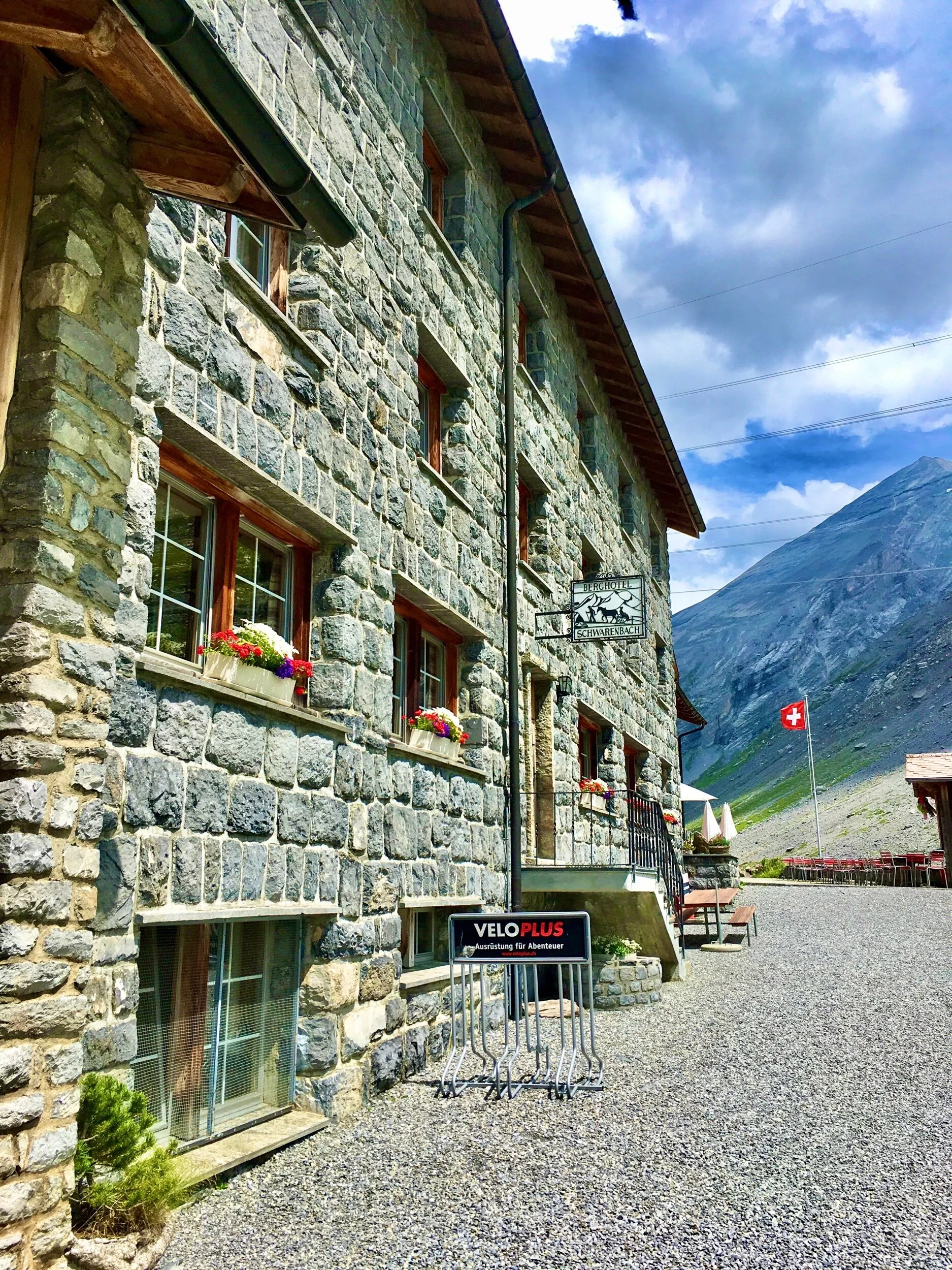
Schwarenbach Hotel
Once past that area, we could easily hike a simple path down to the Schwarenbach Hotel for a much needed restroom break and an ice cream bar. This was basically the end of the hike, even though we still had some flat ground to cover ahead of us.
There are some nice places to take photos along the path, but you’ll mostly be walking past some fields or down a gravel road. It seems closer than it really is, so you’ll be walking quite a while before you arrive at the Sunnbüel cable car which takes you back down to where you started this hike in Kandersteg.
I'm very happy to say that we all made it down safely, with no major injuries and only a few blisters. Was it worth it? Absolutely! Would I do it again? As long as I was wearing the right boots, definitely!
Have you ever hiked the alps? Where do you think we should hike next?


Thank you VERY much for reading our article. We actually created this website to help people reach financial independence. Did you know that by having a remote job and traveling endlessly, or living in a country that has low costs of living, you can actually reach retirement quicker? Plus, retirement abroad is up to 75 percent cheaper as well! Learn more by exploring our website: EatWanderExplore and REmotiFIRE.
Found this post useful? Buy us a coffee to help support this site’s running costs OR share this article with a friend.